
Maps – Example 1
Maps: Example 1
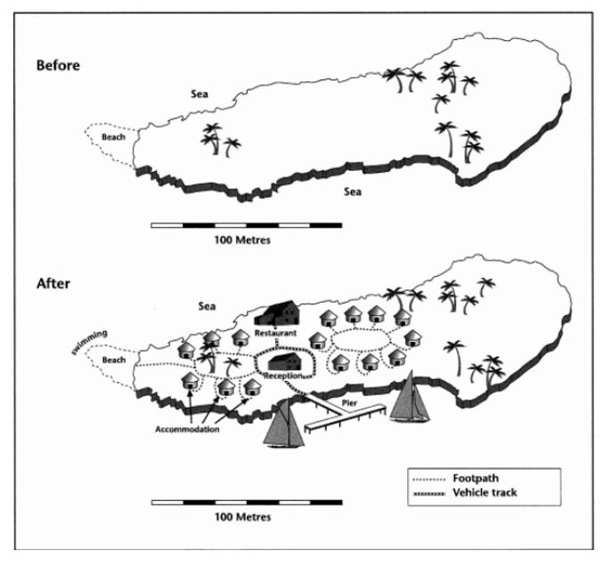
The two maps below show an island, before and after the construction of some tourist facilities.
Summarize the information by selecting and reporting the main features, and make comparisons where relevant.
Write at least 150 words.
Report Plan
Paraphrase: show>compare; before and after construction of some tourist facilities >before and after developments carried out for tourism purposes
Paragraph 1: Overview: The maps compare a small island before and after the developments carried out for tourism purposes.
Paragraph 2: (1) Talk about the overall information. Explain briefly.
Paragraph 3: (1) Compare the before and after scenarios. Give an explanation.
Paragraph 4: (1) Compare the before and after scenarios. Give an explanation.
Sample Answer 1
The maps compare a small island before and after the developments carried out for tourism purposes.
Overall, it is clear that accommodation and other facilities for tourists were built and that a pier was constructed to permit access to the island by boat.
The island was originally undeveloped entirely. Plenty of trees occupied the northern and southern parts. In the central part of the island, two separate accommodation areas were built, consisting of simple huts arranged around a circular footpath. A reception area and restaurant were located in the center of these two areas. Another pathway was constructed, leading to the beach on the western edge of the island and an area for tourists to swim.
Access to the island was made possible by constructing a pier for tourists to land safely by boat. A vehicle track then connected the pier with the reception area and covered a short distance path to the restaurant.
Sample Answer 2
The given map is illustrating changes on an island post the construction of tourist facilities. Before this altered scenario, the island seemed to be a deserted one with no significant tourist facility. However, after the renovation, plenty of tourist amenities were made available, including roads, reception on the island, a variety of accommodations, a restaurant, pier, and more to make the island a tourist-friendly space.
The first map shows emptiness on the island, except for a few trees. However, the second one is displaying all of the changes post construction. A pier could be seen that is constructed for boats. From there, a vehicle track can be spotted, which leads to the reception area and the restaurant. The vehicle track seemingly ends near the restaurant. And then, there is a footpath that leads tourists to the accommodation areas and then to the beach. The residential areas are situated on both sides of the reception with connecting footpaths.
Towards the left side of the reception, a footpath is used to connect the residential area to the beach. Swimming facilities are available with ease. It is worth the notice that no woodcutting was done as trees can be seen in both the maps.